Mariner 10
 |
|
| Operator | JPL - NASA |
|---|---|
| Mission type | Flyby |
| Flyby of | Venus & Mercury |
| Launch date | 3 November 1973 at 05:45:00 UTC |
| Launch vehicle | Atlas-Centaur |
| Homepage | Mariner 10 Home |
| Mass | 473.9 kg |

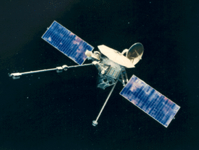
Mariner 10 was a robotic space probe launched by NASA on November 3, 1973 to fly by the planets Mercury and Venus. It was launched approximately 2 years after Mariner 9 and was the last spacecraft in the Mariner program (Mariner 11 and 12 were purposed to the Voyager program and redesignated Voyager 1 and Voyager 2). The mission objectives were to measure Mercury's environment, atmosphere, surface, and body characteristics and to make similar investigations of Venus. Secondary objectives were to perform experiments in the interplanetary medium and to obtain experience with a dual-planet gravity assist mission.
Contents |
Design and trajectory

Mariner 10 was the first spacecraft to make use of an interplanetary "gravitational slingshot" maneuver, using Venus to bend its flight path and bring its perihelion down to the level of Mercury's orbit. This maneuver, inspired by the orbital mechanics calculations of the Italian scientist Giuseppe Colombo, put the spacecraft into an orbit that repeatedly brought it back to Mercury. Mariner 10 used the solar radiation pressure on its solar panels and its high-gain antenna as a means of attitude control during flight, the first spacecraft to use active solar pressure control.
Instruments

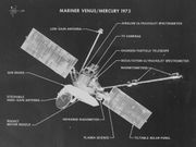
Mariner 10 instruments included:
- Twin narrow-angle cameras with digital tape recorder
- Ultraviolet spectrometer
- Infrared radiometer
- Solar plasma
- Charged particles
- Magnetic fields
- Radio occultation
- Celestial mechanics
Departing the Earth/Moon system
During its first week of flight, Mariner 10 tested its camera system by returning 5 mosaics of Earth and 6 of the Moon. It also obtained photographs of the north polar region of the moon where prior coverage was poor. These provided a basis for cartographers to update lunar maps and improve the lunar control net.[1]
Cruise to Venus
A trajectory correction maneuver was made on November 13, 1973. Immediately following this maneuver the star-tracker locked onto a bright flake of paint which had come off the spacecraft and lost lock on the guide star Canopus. An automated safety protocol recovered Canopus, but the problem of flaking paint recurred throughout the mission, The on-board computer also experienced unscheduled resets occasionally, which would necessitate reconfiguring the clock sequence and subsystems. Periodic problems with the high-gain antenna also occurred during the cruise. In January 1974 Mariner 10 made ultraviolet observations of Comet Kohoutek. Another mid-course correction was made on January 21, 1974.
Venus flyby
The spacecraft passed Venus on February 5, 1974, at a closest range of 5768 km at 17:01 UT. Using a near-ultraviolet filter, it photographed the Cytherean chevron clouds and performed other atmospheric studies. It was discovered that extensive cloud detail could be seen via Mariner's ultraviolet camera filters. Venus's cloud cover is nearly featureless in visible light. Earth-based ultra-violet observation did reveal some indistinct blotching even before Mariner 10, but the detail seen by Mariner was a surprise to most researchers.
 Venus encounter |
 Venus in real colors, processed from clear and blue filtered Mariner 10 images |
 Mariner photograph of Venus in ultraviolet light |
First Mercury flyby
The first Mercury encounter took place at 20:47 UT on March 29, 1974 at a range of 703 kilometres (437 miles).
Second Mercury flyby
After looping once around the Sun while Mercury completed two orbits, Mariner 10 flew by Mercury again on September 21, 1974 at a more distant range of 48,069 km (29,870 mi).
Third Mercury flyby
A third and final encounter, the closest to Mercury, took place on March 16, 1975 at a range of 327 km (203 mi).
|
First Mercury encounter |
 6 hours before closest approach |
 6 hours after closest approach |
 Second Mercury encounter |
 Mosaic of images from the second encounter, covering the equator to the south pole |
 Third Mercury encounter |
 Mercury in color |
 Mercury in black and white |
 Mercury in false-color |
 A prominent scarp, Discovery Rupes, photographed during first flyby |
 Representation of the thrust fault at Discovery Rupes |
 Australia region |
 Aurora region |
 Caduceata region |
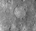
 Old basin, 190 km in diameter, filled by smooth plains. The basin's hummocky rim is partly degraded and cratered by later events |
End of mission
With its maneuvering gas just about exhausted, Mariner 10 started another orbit of the Sun. Engineering tests were continued until March 24, 1975, when the final depletion of the nitrogen supply was signaled by the onset of an un-programmed pitch turn. Commands were immediately sent to the spacecraft to turn off its transmitter, and radio signals to Earth ceased.
Presently, Mariner 10 is still orbiting the sun, although its on-board electronics have probably been damaged by the sun's radiation.[2]
Discoveries
During its flyby of Venus, Mariner 10 discovered evidence of rotating clouds and a very weak magnetic field.
Mariner 10 flew past Mercury three times in total. Owing to the geometry of its orbit — its orbital period was almost exactly twice Mercury's — the same side of Mercury was sunlit each time, so it was only able to map 40-45% of Mercury’s surface, taking over 2,800 photos. It revealed a more or less moon-like surface. It thus contributed enormously to our understanding of the planet, whose surface had not been successfully resolved through telescopic observation. The regions mapped included most or all of the Shakespeare, Beethoven, Kuiper, Michelangelo, Tolstoj, and Discovery quadrangles, half of Bach and Victoria, and small portions of Solitudo Persephones, Liguria, and Borealis.[3]
Mariner 10 also discovered that Mercury has a tenuous atmosphere consisting primarily of helium, as well as a magnetic field and a large iron-rich core. Its radiometer readings suggested that Mercury has a night time temperature of -183°C (-297°F) and maximum daytime temperatures of 187°C (369°F).

Mariner 10 Commemoration
On February 10, 1975, the US Post Office issued a commemorative stamp featuring the Mariner 10 space probe. The 10-cent Mariner 10 commemorative stamp was issued on April 4, 1975, at Pasadena, California.
Notes
- ↑ The Voyage of Mariner 10: Mission to Venus and Mercury (NASA SP-424) 1978 pages 47–53.
- ↑ Mariner 10 (2006) Views of the Solar System
- ↑ Schaber, Gerald G.; John F. McCauley (1980). Geologic Map of the Tolstoj (H-8) Quadrangle of Mercury. U.S. Geological Survey. USGS Miscellaneous Investigations Series Map I–1199, as part of the Atlas of Mercury, 1:5,000,000 Geologic Series. http://astrogeology.usgs.gov/Projects/PlanetaryMapping/DIGGEOL/mercury/h8/h8.pdf. Retrieved 2007-11-12.
External links
- The Voyage of Mariner 10: Mission to Venus and Mercury (NASA SP-424) 1978 This is an entire book about Mariner 10, with all pictures and diagrams, on-line! Scroll down to click on the "Table of Contents" link. PDF version
- 'Mariner 10', NASA's 1973-75 Venus/Mercury Mission
- Mariner 10 image archive
- Mariner 10 Mission Profile by NASA's Solar System Exploration
- Calibrated images from the Mariner 10 mission to Mercury and Venus
- Master Catalog entry for Mariner 10 at the National Space Science Data Center
- Boeing: History -- Products - Boeing Mariner 10 Spacecraft
|
||||||||
|
|||||||||||||||||||||||||||||||
|
||||||||||||||
|
|||||||||||||||||||||||||||||||||||
|
||||||||||||||||||||||||||||||||||||||||||||||||||||||||||||||||||||||||||||||

